Get you up to speed: Australia warns El Nino weather pattern set to be strongest in decades
The Bureau of Meteorology in Australia has warned that a very strong El Niño weather pattern has formed in the tropical Pacific, projected to be one of the strongest in seven decades. Sea surface temperatures have exceeded El Niño thresholds, confirming the intensification of this phenomenon.
The Bureau of Meteorology has indicated that this El Niño event could peak at levels among the highest recorded since 1950, with a significant likelihood of persisting until at least November. The United Nations’ World Meteorological Organization projected an 80 percent likelihood of the phenomenon occurring between June and August 2026, heightening concerns over its potential global impacts.
The Bureau of Meteorology forecasts that the current El Nino event could peak at levels among the highest observed since 1950, prompting widespread concerns over agricultural production in Australia. UN Secretary-General Antonio Guterres has emphasised the need for immediate climate action, stating that “the only effective response is climate action equal to the crisis.”
What remains unclear — It is not specified how El Nino’s intensification might specifically affect Australia’s agricultural exports this year.
Australia’s Bureau of Meteorology warns of strongest El Niño in decades
The Bureau of Meteorology says forecasts point towards a ‘very strong El Nino event’.
Australia’s weather bureau has warned that an El Nino weather pattern has formed in the tropical Pacific and could intensify in the second half of the year, becoming one of the strongest in seven decades.
The Bureau of Meteorology said in a statement on Tuesday that sea surface temperatures in the region had exceeded El Nino thresholds, and atmospheric indicators also suggested the phenomenon has begun.
“Forecasts are pointing towards a strong to very strong El Nino event, based on the extent of warming in the central tropical Pacific,” it said.
“Around half of the models indicate this event could peak at levels among the highest observed since 1950.”
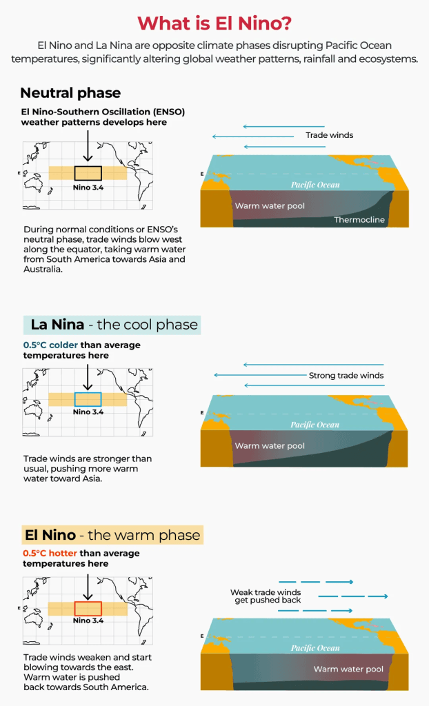
Forecasters expect the weather to bring excessive rain to the Americas and hot, dry conditions to Asia, which is already experiencing crop-planting issues, raising concerns about food supplies.
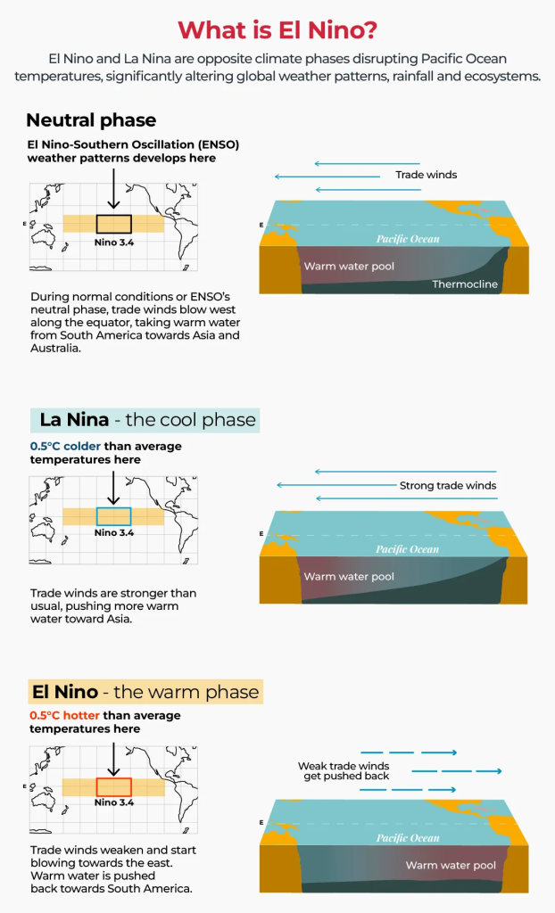
According to the bureau, El Nino is linked to reduced rainfall in winter and spring, particularly affecting Australia’s eastern coast and leading to higher daytime temperatures in the south.
The weather pattern is especially damaging to Australia because it affects agricultural production in the country, which is among the world’s biggest exporters of wheat, sugar and beef.
Scientists have said climate change will supercharge the effects of this year’s El Nino.
The last time Australia experienced an El Nino weather pattern was from 2023 to 2024, and it caused the driest three-month period on record. Before that, one of the strongest events in 2015 and 2016 led to widespread drought and reduced oilseed and grain output.
Historians say past instances of El Nino have caused famines that killed millions, notably in 1877 and 1878.
According to the United Nations’ World Meteorological Organization (WMO), an El Nino weather pattern is characterised by warming of ocean surface temperatures in the central and eastern Equatorial Pacific and typically occurs every two to seven years, lasting about nine to 12 months.
In a report on June 2, the WMO found that there was an “80 percent likelihood of an El Nino event during June-August 2026″.
“Probabilities for this to continue until at least November are near or above 90 percent,” it said, adding that the weather pattern was set to impact global temperature and rainfall patterns, increasing the risk of extreme weather.
UN Secretary-General Antonio Guterres also warned in a video message following the publication that the world must treat this as “the urgent climate warning it is”.
“The only effective response is climate action equal to the crisis – ending the addiction to fossil fuels, accelerating the shift to renewables, protecting the most vulnerable, and delivering early warning systems for all,” he said.


Great article! This really puts things into perspective. I appreciate the thorough research and balanced viewpoint.
Interesting read, though I think there are some points that could have been explored further. Would love to see a follow-up on this topic.
Thanks for sharing this! I had no idea about some of these details. Definitely bookmarking this for future reference.
Well written and informative. The examples provided really help illustrate the main points effectively.
This is exactly what I was looking for! Clear, concise, and very helpful. Keep up the excellent work!